The Coleridge Way
The Coleridge Way covers some 51 miles through the stunning Somerset countryside of the Quantock Hills, the Brendon Hills and Exmoor. It is a landscape that inspired the Romantic poet Samuel Taylor Coleridge to produce some of his best known work.
Walking the Coleridge Way: From Somerset to the Sea at Lynmouth
The Coleridge Way is a 51-mile walking trail that traces the poetic footsteps of Samuel Taylor Coleridge, winding through quiet hills, ancient woodlands, and expansive moorland before arriving at the dramatic coastal village of Lynmouth. It’s a route rich with literary history and natural variety, offering a journey that shifts with every mile—culminating in one of the most atmospheric coastal settings in England.
What is the Coleridge Way?
The Coleridge Way begins in Nether Stowey, Somerset, where Coleridge once lived, and leads westward through the Quantock Hills, across the Brendon Hills, and deep into Exmoor National Park. The path ends in Lynmouth, where the rivers East and West Lyn tumble down from the moor and meet the sea. It’s a walk of contrasts—rolling farmland, wooded combes, wind-blown heather moor—and it follows terrain that once inspired the earliest works of English Romanticism.
Highlights Along the Route
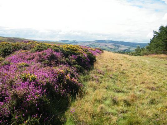
Nether Stowey and the Quantocks
Begin at Coleridge Cottage, the 18th-century home where the poet wrote The Rime of the Ancient Mariner. From there, follow sunken green lanes and heathered hillsides through the Quantocks, one of England’s first designated Areas of Outstanding Natural Beauty.
Brendon Hills and Rural Villages
Moving westward, the route passes through quiet villages like Holford, Roadwater, and Luxborough, offering timeless thatched cottages and welcoming inns. The landscape here is more agricultural—rolling fields, coppiced woodland, and occasional red deer crossing the trail.
Exmoor High Points
From Wheddon Cross, the trail climbs to Dunkery Beacon—Exmoor’s highest summit at 1,705 feet. On clear days, you can see the Bristol Channel to the north and the distant hills of Dartmoor to the south.
Porlock to Lynmouth: A Wild Coastal Finish
This final section threads through ancient Horner Woods, past Porlock Weir, and along the cliffs near Culbone Church, reputedly England’s smallest parish church. From here, the route merges briefly with the South West Coast Path, ascending rugged coastal headlands before descending dramatically into Lynmouth—a place of sea spray, salt air, and stories.
Ending in Lynmouth: Where Moor Meets Sea
Few trail endings feel as complete as the descent into Lynmouth. The wooded valleys fall steeply into a narrow coastal gorge, and the sound of rushing rivers gives way to waves against the harbour wall. Grab fish and chips by the water, ride the cliff railway to Lynton, or simply soak in the view—this is a place that feels earned.
Lynmouth also makes a convenient base for a night or two post-walk. It offers a range of accommodation, from small hotels to hiker-friendly B&Bs, plus plenty of places to relax, refuel, and reflect.
Practical Tips for Walking the Coleridge Way
Distance: Approx. 51 miles / 82 km
Duration: 4–6 days depending on pace and overnight stops
Waymarking: Feather quill on dark brown background
Terrain: Mixed—expect moorland, woodland tracks, coastal climbs
Luggage transfer available (link to be added)
Bring good waterproofs and sturdy boots—the weather on Exmoor can change quickly, and paths can be muddy in wet seasons. GPX files and trail maps are available from regional tourism hubs or walking guidebooks.